

Beinisbhal [Benisval]
Good walks are even better shared.
Overview
Beinisbhal [Benisval]
Overview
Nestled in the breathtaking Scottish Highlands, Beinisbhal, often referred to as Benisval, rises majestically to 586 meters. This Marilyn may not be the tallest of its cousins, but its unique charm and stunning vistas make it a must-visit for any keen hiker or outdoor enthusiast.
Geology
The mountain boasts ancient Lewisian Gneiss rock formations, adding a rich geological layer to its allure. As you ascend, take a moment to appreciate the fact that these stones have weathered 3 billion years, which is considerably longer than most of us can remember!
Routes
There are several routes to the summit, each providing its own experience:
- Southern Approach: This is a moderate hike of about 5 km via established paths that let you enjoy the surroundings without gasping for air.
- Northwest Ascent: A more challenging route that brings a bit of grit to your hike, rewarding you with exhilarating views that are well worth the effort.
Summit Features
Upon reaching the summit, hikers are greeted by a charming stone cairn and a trig point – a perfect excuse for a selfie to show your mates back home that you’ve conquered another peak!
Terrain
Expect a mix of rocky outcrops and grassy slopes, interspersed with the occasional bog. There’s nothing quite like squelching through mud to remind you that you’re properly outdoors!
Views
From the top, the panoramas are simply breathtaking. Look out over the hills and if you’re lucky enough to visit on a clear day, you can even catch sight of the Western Isles. Best to have your camera ready!
Hazards
Be cautious of the rugged terrain, as a misstep could spoil an otherwise perfect day. Remember, the Scottish weather is as unpredictable as a cat at bath time, so check conditions before you head out.
Access
Parking at the road end near Loch Rimsdale gives you the ease of access needed for this adventure. Should you find yourself without wheels, the nearest bus service through Durness might help – though be prepared for a journey! Tongue is the closest town you can fall back on for any necessary provisions.
Facilities
Before or after your hike, a visit to Tongue can provide you with all the amenities necessary – grab a hearty meal and maybe even share a tale or two with the locals.
History
The name Beinisbhal, deriving from Gaelic, highlights its local heritage and connection to the surrounding salt marsh. Rich in folklore, this mountain is not just a pile of rocks – it holds stories of spirits and local legends.
Now that you've got the lowdown on Beinisbhal, there’s really only one thing left to do – lace up those boots and hit the trails! Happy hiking!
Explore routes near Beinisbhal [Benisval]
Public walks starting within 80 km of this hill. Nearby does not mean a route reaches the summit; check its map and access before setting out.
Beautiful private beach walk Isle of Harris
View route
Berneray Community Hall to the beautiful beach
View route
Route planning notes
These notes describe possible approaches, not verified navigable routes or permission to cross land. Check current paths, local access rules and conditions before setting out.
Southern Approach
A straightforward hike from the south, offering gradual ascent along well-established paths. Perfect for those who prefer stretching their legs without breaking a sweat.
Northwest Ascent
A somewhat steeper trail that rewards hikers with stunning views over the surrounding landscape. Prepare for a bit of a puff but worth every breath!
Make a day of it, together
Find someone to share the walk with, or organise a day out along a route you like.
Photo Gallery
View all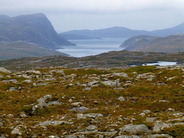 Photo could not load
NB0918 : View Towards Taran Mòr
Rude Health
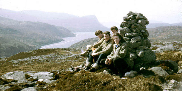 Photo could not load
NB0918 : Summit cairn of Beinisbhal
Julian Paren
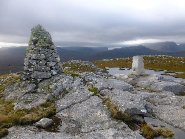 Photo could not load
NB0918 : Benisval Cairn and Trig Point
Rude Health
Hill facts and local notes
Classifications
Elevation
190m
623 ft
Prominence
109m
Coordinates
58.0610, -6.9251
NB096185
OS Map
13 14
Explorer: 456
At the Summit
The summit features a stone cairn, which is perfect for posing for a picture to make your friends envious. There's also a small trig point for those who enjoy a bit of triangulation.
Terrain & Geology
Beinisbhal is predominantly composed of ancient metamorphic rock called Lewisian Gneiss, which makes it a geological gem. These rocks date back approximately 3 billion years and offer a fascinating glimpse into the Earth's history.
Views & Scenery
From the summit, one can observe the majestic peaks of the surrounding hills along with sweeping views of both land and sea, including vistas of the Western Isles on a clear day.
History & Heritage
Name Origin
The name Beinisbhal translates from Gaelic as 'mountain of the salt marsh', a fitting tribute to the landscape that surrounds it.
Historical Significance
Beinisbhal holds significance in local folklore and is often mentioned in tales of local spirits and folklore.
Getting There & Facilities
Check current local access restrictions, parking rules and transport timetables before travelling. These notes do not confirm public access to the summit.
Parking
Parking is available at the road end near Loch Rimsdale, providing easy access to the trailhead.
Public Transport
Limited public transport is available; the nearest bus service passes through the village of Durness. Further connections to larger towns may be needed.
Nearby Facilities
Facilities are available in Tongue, including cafes, shops, and toilets. It's a good idea to refuel with a hearty meal before your adventure.
Safety Information
Known Hazards
- Rugged and uneven terrain can pose a risk for slips and trips; be sure to watch your footing. Weather can change rapidly, so bring layers and check conditions.
General Safety Tips
- Check weather conditions before setting out
- Carry appropriate clothing and equipment
- Let someone know your planned route
- Take a map, compass, and GPS device
- Carry emergency supplies: food, water, first aid kit, torch
Hills
Some common questions about the hills answered
Are there group walks up Beinisbhal [Benisval]?
Many walkers use Walkmates to join or organise walks with others. You can check for group walks around Beinisbhal [Benisval] through the maps
Are there other walkers around Beinisbhal [Benisval]?
Activity varies by location and time, but Walkmates lets you see whether others have shared walks or shown interest in this area. Find other people through the walking friends search walking friends for Beinisbhal [Benisval] search or of course create your own walk for Beinisbhal [Benisval]
Can I organise a walk to Beinisbhal [Benisval]?
Yes. If there aren’t any walks listed already, you can create a walk and make it available for others to join.
If you're signed up to Walkmates, you can create a walk to Beinisbhal [Benisval].
How do I find a walk up this hill?
There are often multiple ways to walk this hill, depending on experience and route preference. Walkmates helps you explore walks and routes that others have shared.
Can I suggest a new route up Beinisbhal [Benisval]?
Yes. You can suggest or create routes to share with others. Walkmates focuses on the social side of walking, so routes are used to help people organise walks and explore areas together, rather than as detailed navigation tools or route libraries.
Other uses really appreciate knowledgeable walkers sharing their routes. Share your favourite route to Beinisbhal [Benisval] here
The is an error or something incorrect about this hill. How do I let you know?
We always strive to keep the information on Walkmates as accurate as possible. If you find an error, please let us know through the contact form and we'll aim to correct it as quickly as possible
Community Discussion
Comments
Location
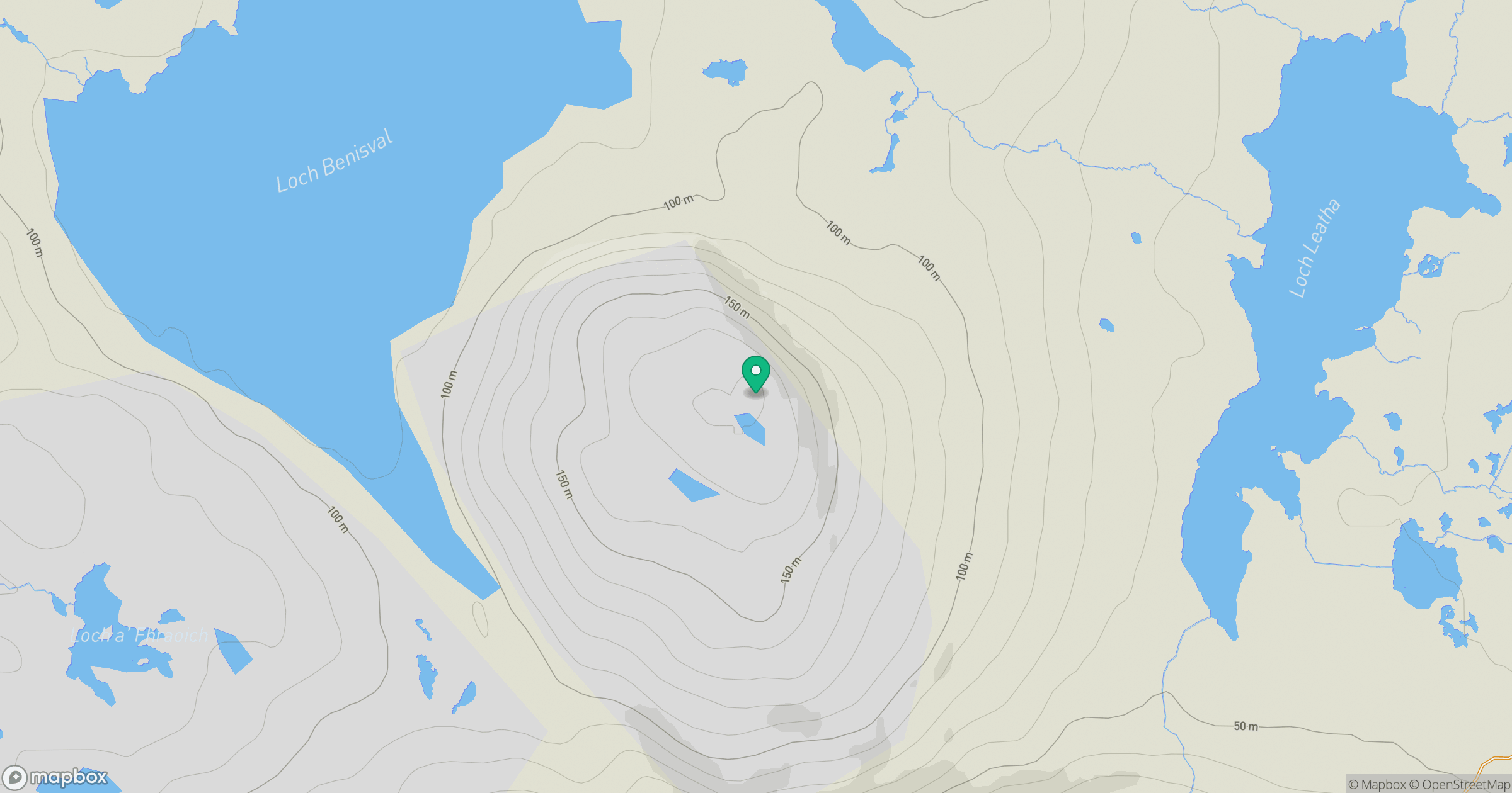
Grid reference: NB096185
View on OpenStreetMapOpens a map in a new tab, centred on the hill.
Hills within 30 km
Straight-line distance, not a walking route or confirmation of access.
An Cliseam [Clisham]
800m
Beinn Mheadhanach [Beinn Mheadhonach]
397m
Coduinn
241m
Sgalabhal [Scalaval] [Scalabhal]
260m
Oireabhal [Oreval]
662m
No comments yet. Be the first.